

The church is large for such a small village and stands proudly on the top of the hill at South Weald, two miles from Brentwood in the English county of Essex. The Saxons settled here and the place is mentioned in the Domesday Book. St Peter’s is the mother church of the neighbourhood and until the middle of the 19th century, Brentwood, with its chapel, came under the jurisdiction of South Weald. The present church dates from about 1150, although the South Door with its chevron ornamentation is the sole remaining Norman feature. The present Memorial Chapel at the end of the south aisle was originally Weald Hall Chapel. Within it are commemorated former holders of the manor of South Weald. Sir Anthony Browne, the founder of Brentwood School, Erasmus Smith and the Tower family are all represented. The latter were the local squires from 1752 onward.
The East Window
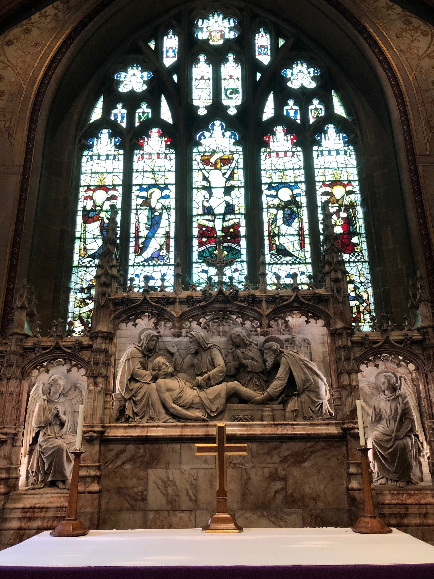 The East Window was erected by subscription in 1886 in memory of the Rev Charles Belli. The centre light represents the Crucifixion. On either side are the figures of the Virgin Mary and St John.
The two outside lights contain St Peter and St Paul. The tracery is filled with angels and shields symbolic of our Lord’s passion – the nails, the hyssop, the scourge, the crown of thorns, the seamless robe, the dice and the spear.
The alabaster reredos was added in 1885 and depicts the entombment of our Lord. Nicodemus, Mary Magdalene and Joseph of Arimathaea are shown. It is clearly a later addition as it covers up part of the Ten Commandments which were put up at the time of the restoration.
The altar was brought forward in 1983, the work having been commissioned in memory of Mrs H. P. Bradshaw.
The South Doorway
This fine doorway has happily survived, despite the various restorations of the church and in particular, that of 1868. It is perhaps the greatest architectural feature of the building.
It dates from the Norman building of 1150 and is a typical semi-circular arch of the period. A segmental arch at the bottom supports a tympanum with axe worked ornamentation and above are two arches, the lower plain and the upper with a chevron decoration
Thank you to Bill Wilford for providing us with this article.
The Porch
The porch dates from the restoration of 1868. it replaced an older, larger one which was removed. Canon Duncan Fraser, a former vicar, writing at the end of the 19th century, told of John Stutt, the Church Clerk of South Weald who died in 1855.
He used to conduct a school in the old porch and canvas screen and doors were erected to keep out the cold winds, a small stove was used and forms and desks put in place on Monday mornings and cleared away at the end of the week.
On his death, the Vicar, the Rev Charles Almeric Belli, had a stone erected at his grave, which is near to the path from the car park entrance. Turn right after passing a bush, go up the bank and it is the second grave on the right.
Thank you to Bill Wilford for providing us with this article.
The Environs – By Bill Wilford
The Tower family graves are situated in an enclosed area in the north-west of the church yard and a private gate from the park gave the family access. Opposite the church tower is the door through which the squire, his family and servants came from Weald Hall to worship. The house, a fine Tudor mansion, stood nearby in the park until 1950, when it was demolished, having fallen into disrepair after standing empty for four years.
Opposite the church is the Tower Arms, a splendid example of early 18th century architecture. Above the entrance are the initials ALAA and the date 1704. The house was originally called Jewells. In earlier times, the village public house was on the west side of the church and was known as the Spread Eagle until about 1878 when it was re named the Tower Arms. The licence had been transferred to the present house by 1921.
Following the road to the right outside the lychgate, there are two entrances to Weald Country Park. Between them, on the right, is a house now known as Queen Mary’s chapel. In the 16th century, Weald Hall was surrounded by a series of walled courts and gardens and included this garden house, built in the same style as Weald Hall. There is a tradition that Queen Mary worshipped there secretly before her accession, but there is no contemporary evidence in support.
Enter the park at the second of two entrances and you will be near to the visitors centre with information and literature about Weald Hall and Weald Park. The Park was formed as a deer park in the 12th century, when the monks of Waltham abbey held the manor. Deer were kept here until 1944, when troops were assembling for the invasion of France and the fences were breached to enable vehicles to enter. The deer escaped. A herd is at present being re-established. With its lakes, the park presents a fine vista and is well worth a visit. On the eastern side of the park, bordering Sandpit Lane, is part of South Weald Fort. This is an Iron Age fortification and has been excavated recently.
Returning to the village, take the right turn into Wigley Bush Lane. It appeared thus on Chapman and Andre’s map of Essex of 1777 and was revived in the 1970’s after a period when the name was Vicarage Lane.
On the left hand side of the road is Luptons, an early 18th century house which was inhabited by Edward Ind in 1848. He was a partner in the Ind Coope brewery in Romford. His partner, Octavius Coope MP lived at Rochetts, the entrance to which is opposite Queen Mary’s chapel. It was largely destroyed by fire in 1975. Opposite Luptons is Wealdcote, a 16th century building, to which was added a 17th century extension.
Further down on the right hand side is the school, built between 1957 and 1968 to replace the original building which stood opposite the present church car park and is now demolished. On the left hand side are the almshouses. Ten of these, together with a chapel, were designed by S S Teulon and built in 1854. They were originally established in 1567, through benefactions in the will of Sir Anthony Browne. Two additional almshouses were added in 1966.
Continuing towards Brentwood, the present vicarage, dating from about 1926, is on the right and replaced Weald Hall as the vicar’s residence. The name is misleading, as the original Weald Hall was in Weald Park. The house dates from 1825 and was built as a vicarage by Charles Belli, whose munificence restored the church and built the school in the village.
After crossing the bypass, Brook Street is reached at the junction with the main road. This was probably the route of the Roman road from London to Chelmsford and Maldon. The Nags Head, built in the 18th century, gives its name to the lane opposite. It was so called in 1777.
Turning left towards Brentwood, Stone house is encountered on the left after about 200 yards. An unusual site, it was built about 100 years ago of random brick, stone and flint. Adjoining the house is a row of early 18th century cottages, succeeded in turn by the Bull, probably another 18th house. At the traffic lights, Spital Lane commemorates the leper hospital which stood on the corner from the 12th to the 16th centuries.
Two of Brook Street’s oldest buildings are reached within 200 yards. On the left is the Golden Fleece, a large 15th century building which is now a restaurant. The remains of the original hammerbeam hall roof are clearly visible from the vestibule of the dining room. Almost opposite is the Mary Green Manor Hotel. It had been known as ‘The Place’ in 1514, but was completely rebuilt in the 17th century.
Excerpt taken from “Essex Town and Country” printed 1992.
ISBN 1 85306 155 7.
South Weald’s entry compiled and written by B. Wilford.